
Know Your Ground
Know Your Ground
Water Table Depth by Zip Code: How to Look Up Ground Water Levels Near You
Find water table depth by zip code using free USGS tools and state databases. Know your groundwater level before you buy land or drill a well.

Water Table Depth by Zip Code: How to Look Up Ground Water Levels Near You
You're looking at a piece of land. The price is right. The location works. But before you sign anything, you want to know one thing: is there water under the ground?
Checking the water table depth before you buy land is one of the smartest moves you can make. A high water table can ruin your septic system plans. A water table that's too deep can mean a well costs twice what you expected. And in some areas, the groundwater is so shallow that your entire property floods from below when it rains.
The good news: you can check groundwater levels for free, from your phone or computer, before you spend a dollar.
Water table depth is how far below the ground surface the first major layer of saturated groundwater sits. In the United States, the U.S. Geological Survey (USGS) monitors more than 15,000 active groundwater wells across all 50 states. That data is public, real-time, and free to search by location. Checking it takes about 15 minutes. Skipping it can cost you tens of thousands of dollars.
This guide walks you through four free tools to look up water table depth by zip code or address, what those numbers mean for your land, and the state-specific patterns Andrew and Felicia have seen after selling 800+ properties since 2017.

Why Water Table Depth Matters for Land Buyers
Most land buyers think about water in one of two ways: "Can I drill a well?" and "Does it flood?"
Both questions trace back to the same thing: where the water table sits.
The water table is not a fixed line. It rises and falls with rain, drought, and season. In some areas, it rises several feet in spring and drops in summer. That's important because county permits and building codes are based on seasonal high water table readings, not average readings.
Three ways water table depth affects your land:
Well drilling cost: The deeper you have to drill to hit water, the more it costs. According to WaterFilterGuru, drilling a residential water well in the U.S. costs between $15 and $55 per foot, all-in. A 100-foot well might cost $3,000. A 500-foot well in a dry region could run $15,000 or more (checked October 2026). Knowing the expected depth before you buy tells you what you're paying for water.
Septic system viability: Most counties require at least 18 to 24 inches of separation between the bottom of a septic drain field and the seasonal high water table. If the water table is too close to the surface, a standard septic system won't pass inspection. You'd need an elevated mound system, which costs two to three times more than a conventional one.
Flood and wetland risk: When the water table sits close to the surface, rain has nowhere to go. The ground saturates fast. Properties with a seasonal high water table of 12 inches or less often sit in or near wetlands. That matters a lot for what you can build. Our guide to Florida wetlands and land buying covers exactly what happens when buyers skip this check.
The 4 Best Free Tools to Check Water Table Depth by Zip Code
You don't need to hire a hydrogeologist. These four tools are free, government-backed, and searchable by location.
1. USGS Groundwater Watch (waterdata.usgs.gov)
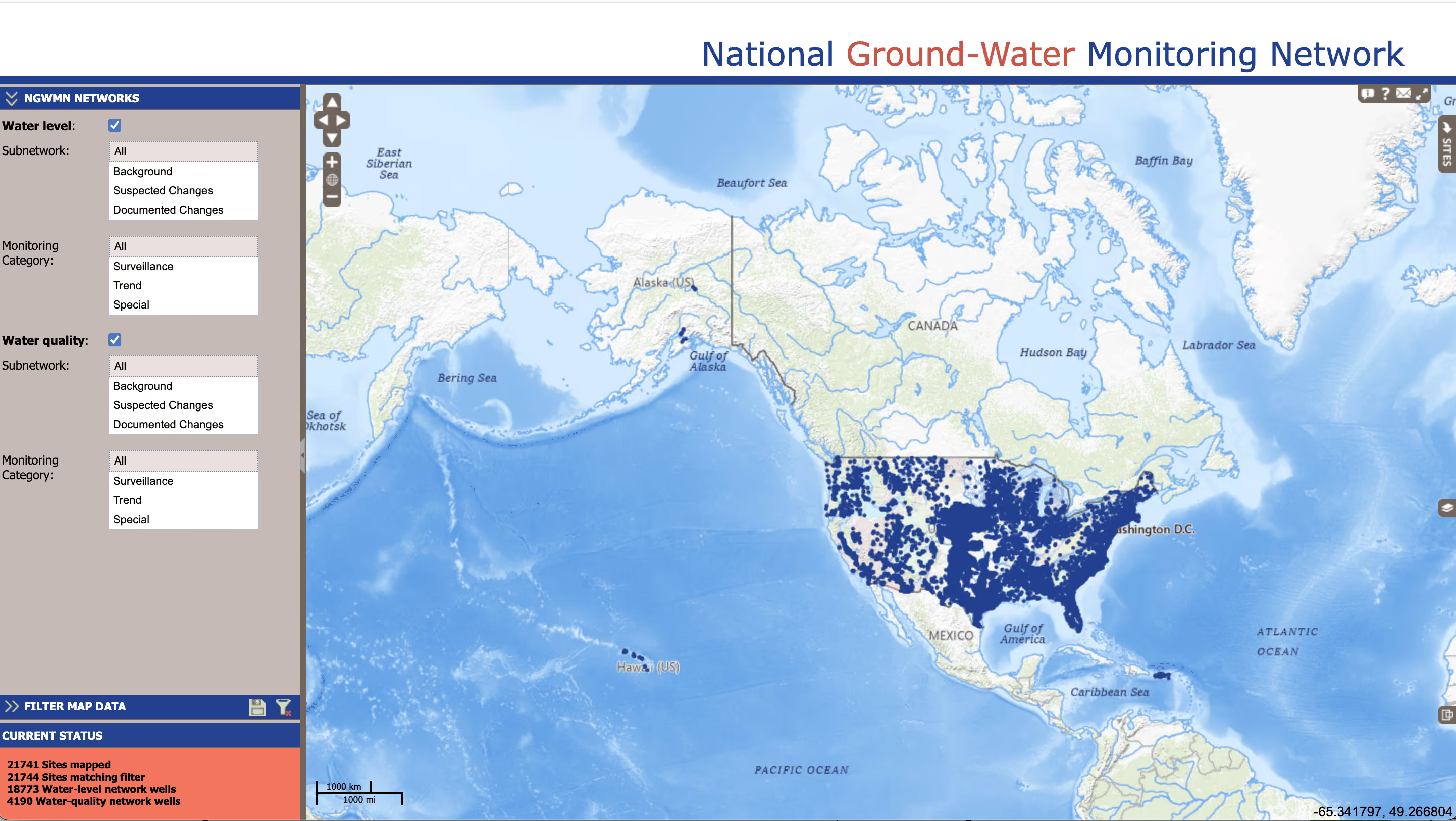
The USGS National Groundwater Monitoring Network is the most authoritative source for water table data in the country. It pulls real-time readings from thousands of monitoring wells and displays them on an interactive map.
How to use it:
Go to waterdata.usgs.gov/nwis/gwlevels. Zoom in to the area of your property on the map. Blue and green dots represent monitoring wells. Click any dot to see the current depth to water, historical readings, and charts showing seasonal fluctuations.
The data shows depth in feet below land surface. A reading of "15.4 feet" means the water table is currently 15.4 feet underground at that monitoring well.
Limitation: Monitoring wells are spread out. The closest one to your property might be a mile or two away. Use this data as a directional indicator, not a precise measurement for your exact parcel.
2. DrillerDB Well Map (drillerdb.com/well-map)
DrillerDB aggregates state well completion reports from across the country and maps them by location. When a well driller completes a new well, they're required in most states to file a well completion report with the state. Those reports include the depth they had to drill before hitting water.
Why this is useful: Unlike USGS monitoring wells, DrillerDB shows you actual drilled wells from homes and properties in the same area as yours. If a neighbor 300 feet away drilled a 150-foot well to hit water, that's a strong signal about what you'd face.
Search by address or zip code. Results show well depth, completion date, and water yield information when available.
3. Your State Water Agency Database
Most states maintain their own groundwater databases, updated more frequently than federal sources. Felicia, co-founder of Compass Land USA, recommends always checking your state agency as a first stop because the data is often more local and more recent than national tools.
Here are the state databases most relevant to CLUSA buyers:
- Arizona: Arizona Department of Environmental Quality (ADEQ) Well Registry at azwellregistry.azdeq.gov
- Colorado: Colorado Division of Water Resources Well Permit Search at dwr.colorado.gov
- Florida: Florida Department of Environmental Protection well records at floridadep.gov
- Nevada: Nevada Division of Water Resources Well Log Database at water.nv.gov
- New Mexico: New Mexico Office of the State Engineer well log database at ose.state.nm.us
Each database lets you search by address, parcel ID, or zip code. You're looking for well completion reports filed by previous drillers in the same area.
4. American Geosciences Institute FAQ + Local Driller Contacts
The American Geosciences Institute maintains a public FAQ at americangeosciences.org that explains how to read groundwater data and what depth ranges mean in different geological settings.
The single best step you can take beyond these tools: call a local well driller. Drillers who work in a specific county know that county's water table by memory. A five-minute phone call with a licensed driller in the county where your land sits will tell you more than an hour of map research. Ask them: "I'm looking at land in [area]. What depth are you typically hitting water at? What's the seasonal variation?"

How to Read the Numbers: What Different Depths Mean
Once you have a water table depth reading, here's how to translate it into practical land-use terms.
0 to 18 inches below surface:This is a very shallow water table. Properties at this level are often classified as wetlands. Building anything, including a home or septic system, will face serious permitting obstacles. This is a red flag for most buyers unless you specifically want a wetland property for hunting, fishing, or conservation purposes. Check our full guide on checking property for wetlands and flood zones before proceeding.
18 inches to 5 feet below surface:Still shallow. You may face difficulty getting conventional septic permits. Check your county's seasonal high water table requirement. You'll likely need a site-specific perc test. Well drilling cost at this depth is low, but water quality can be an issue because shallow aquifers are more vulnerable to surface contamination.
5 to 50 feet below surface:This is a common range for many areas. Septic systems are usually viable. Well costs are moderate. This depth range is what most buyers in the Southeast and parts of the Midwest encounter.
50 to 300 feet below surface:Standard for much of the country. Well drilling at this depth costs $3,000 to $10,000 depending on your state and local geology. Septic is almost always viable. This is a normal, workable range.
300 feet and deeper:Common in arid western states like Arizona and Nevada. Drilling at this depth adds significant cost, often $10,000 to $25,000 or more. Some remote areas in the Southwest have water tables at 800 to 1,000 feet. In these areas, solar-powered well systems and water storage become important parts of the plan. Our resource on checking utilities on vacant land goes deeper on this.

State-by-State Water Table Patterns: What We've Seen
After helping buyers across five states, Andrew and Felicia have seen consistent patterns that the maps don't always make obvious.
Arizona: Water tables run deep, often 300 to 800 feet in rural desert areas. Active management areas (AMAs) in Maricopa, Pinal, and Pima counties regulate groundwater pumping. If you're buying land in an AMA, check whether a water rights certificate comes with the property. Browse CLUSA's Arizona land inventory to see properties where we've already vetted water access.
"In Arizona, the first question we ask about any property is the water situation," says Andrew, co-founder of Compass Land USA. "We've seen buyers fall in love with a parcel only to find out the nearest water source is 600 feet down and the drilling permit is restricted. That's not a deal-killer if you know ahead of time, but it changes your budget by $15,000 or more."
Colorado: Highly variable. The Eastern Plains have deep water tables and active groundwater disputes. Mountain and Front Range areas can have shallow tables due to snowmelt. Always check whether the property has a well permit issued. Colorado water law is complex: you often need a permit before drilling, and permits are not guaranteed. Visit dwr.colorado.gov to search permit records.
Florida: Florida has one of the shallowest average water tables in the country. In many parts of Central and South Florida, the water table sits 1 to 4 feet below the surface. This is good for well access but creates major issues for septic. It also creates flooding risk during rainy season. Our Florida wetlands guide explains how to check whether your specific parcel has seasonal flooding or wetland designations.
Nevada: Similar to Arizona: deep, dry, and variable. Many rural Nevada parcels have no practical path to a drilled well. Buyers plan for water hauling, storage tanks, or rainwater collection (check county rules first). See what's available in our Nevada land listings.
New Mexico: Water table depths range widely. Northern New Mexico near rivers can have workable shallow aquifers. Southeastern New Mexico is much drier. The New Mexico Office of the State Engineer has jurisdiction over all water rights, and drilling a well requires a permit. Some rural areas have water rights issues that predate current ownership.
"The buyers who have the best experience are the ones who research water before they make an offer. Not after. The ones who skip it are the ones who call us six months later wondering why their well cost $20,000 more than they expected."— Andrew, Co-founder of Compass Land USA

Red Flags to Watch For
Not all groundwater problems are obvious from a map. These are the warning signs that should prompt deeper research before you buy.
The listing says "no water on property." This is honest disclosure. It means no well has been drilled and the seller isn't making any claims. That's fine, but it puts the research burden entirely on you. Pull the state well log database and look for neighbor wells within a mile. If there are none, that's a meaningful data point.
The property is in a designated groundwater basin with restrictions. Arizona's Active Management Areas and Nevada's hydrographic basins have rules about who can drill and how much they can pump. Run the address through the state agency database before you fall in love with a property.
The USGS map shows a monitoring well nearby that's flagged red or yellow. These flags indicate that water levels are significantly below historical averages. In the Southwest, that often means the aquifer is being drawn down faster than it recharges. Our guide to checking property access and utilities covers what to do with this kind of information.
The seller says a well is already on the property but no records exist. Ask for the well completion report. Every permitted well should have one. If the seller can't produce it, request it from the state database. If no record exists, that well may not be permitted, which can cause problems when you go to develop the property.
For a complete walkthrough of land due diligence steps, including water, access, zoning, and title, start with our full land buying due diligence checklist.

Frequently Asked Questions
How deep is the water table by zip code?
Water table depth varies significantly by location. You can find the water table depth near any zip code using the USGS Groundwater Watch map at waterdata.usgs.gov, or by searching your state's well log database for completed wells in the same area. There is no single national zip-code lookup, but USGS monitoring wells and state driller records together give you a strong picture of what to expect.
Where can I find a water table depth map by zip code?
USGS Groundwater Watch (waterdata.usgs.gov) and DrillerDB (drillerdb.com/well-map) are the two best national maps. Your state water agency also maintains its own map, often updated more frequently. Links to all five CLUSA-state databases are listed above.
Does the water table affect my ability to get a septic system?
Yes, significantly. Most counties require the seasonal high water table to be at least 18 to 24 inches below the bottom of the septic drain field. If the water table is too shallow, you'll need an alternative system, often a mound system, that costs $15,000 to $30,000. Check your county health department's rules before buying any land where you plan to install a septic system. Our guide on checking property access and utilities has more on this.
How much does well drilling cost if the water table is deep?
Well drilling typically costs $15 to $55 per foot, including casing, pump, and installation. A 200-foot well might cost $6,000 to $8,000. A 600-foot well in a dry desert area can run $20,000 to $30,000. That's why knowing the expected depth before you buy is so important. It's a cost that varies by location more than almost any other part of land development.
Can I find the water table depth for free?
Yes. The USGS Groundwater Watch map, state well log databases, and DrillerDB are all free. The only cost is your time. If you want a site-specific test on your parcel, you can hire a licensed hydrogeologist or driller for a more precise estimate, but most buyers get enough information from the free tools to make a sound decision.
You Can Figure This Out Before You Buy
Checking the water table is not complicated. It takes about 30 minutes with the free tools listed above, and it tells you something critically important about a property's potential.
The buyers who skip this step aren't bad buyers. They just didn't know where to look. Now you do.
If you have questions about water access, well drilling, or whether a specific CLUSA property is right for your goals, call or text Andrew anytime at (313) 349-0434. That's what we're here for. And when you're ready to browse properties where we've already done the legwork on access and utilities, start at compasslandusa.com.
Andrew
Co-founder, Compass Land USA
Andrew co-founded Compass Land USA after buying and selling land for years without needing a single bank. He's been on both sides of hundreds of owner-financed deals across five states.
You've Read Enough. Time to Own Something.
Ready to Stop Renting Your Life and Start Owning Something?
Browse available land in Arizona, Colorado, Florida, Nevada, and North Carolina. Owner financing on every parcel. No bank. No credit check. Close in days.
